 Home
Latest news
Home
Latest news
Championships winners
Next briefing v11
Next briefing v10
Task 8 start order
Next briefing v9
Next briefing v8
Cancel bouncing
Next briefing v7
Next briefing
No fly zone changes
Weather
Task 1 start order
Gates at airfield
Local intranet access
Notes on PMR446 radios
WPC 2009 mail list
Official documents
Open National Championships
Permitted radios
Task catalogue v3
Local regs v3
Local regs & Task catalogue v3
Tasks
Task 7 info
Task 10 info
Task 10 A4 EXAMPLE
Task S
Document manifest
Task L
Task 9 info
Task 8 info
Task 4 info
Task 6 info
Task 5 info
Task 3 start order
Task 2 start order
Task 3 info
Task 2 info
No-fly zones
Task 1 info
Task T
Task management
Task check lists
Task R
Task P
Task Q
Task O
Task N
Fuel control procedure
Task M
Task J
Electronic devices declaration
Flight recorder procedure
Task K
Electronic devices procedure
Task I
Ordered takeoff procedure
Task H
Task C
Task D
Task E
Task F
Task G
Task B
Task A
Ordered start procedure
Task 99 info example
PF1 scores
PF1 TOTALS v12
PF1 Task 7 v2 OFFICIAL
PF1 Task 6 v2 OFFICIAL
PF1 Task 5 v3 OFFICIAL
PF1 Task 4 v2 OFFICIAL
PF1 Task 3 v3 OFFICIAL
PF1 Task 2 v2 OFFICIAL
PF1 Task 1 v3 OFFICIAL
PF1 TOTALS v11
PF1 Task 7 v1
PF1 TOTALS v10
PF1 Task 6 v1
PF1 TOTALS v9
PF1 Task 5 v2
PF1 TOTALS v8
PF1 Task 5 v1
PF1 Distance grid v1
PF1 TOTALS v7
PF1 TOTALS v6
PF1 Task 4 v1
PF1 TOTALS v5
PF1 Task 3 v2
PF1 TOTALS v4
PF1 Task 3 v1
PF1 TOTALS v3
PF1 Task 1 v2
PF1 TOTALS v2
PF1 Task 2 v1
PF1 TOTALS v1
PF1 Task 1 v1
PL1 scores
PL1 TOTALS v9
PL1 Task 7 v2 OFFICIAL
PL1 Task 6 v2 OFFICIAL
PL1 Task 5 v2 OFFICIAL
PL1 Task 4 v2 OFFICIAL
PL1 Task 3 v2 OFFICIAL
PL1 Task 2 v2 OFFICIAL
PL1 Task 1 v2 OFFICIAL
PL1 TOTALS v8
PL1 TOTALS v7
PL1 Task 7 v1
PL1 TOTALS v6
PL1 Task 6 v1
PL1 TOTALS v5
PL1 Task 5 v1
PL1 TOTALS v4
PL1 Task 4 v1
PL1 TOTALS v3
PL1 Task 3 v1
PL1 TOTALS v2
PL1 Task 2 v1
PL1 TOTALS v1
PL1 Task 1 v1
PF2 scores
PF2 TOTALS v8
PF2 Task 7 v3 OFFICIAL
PF2 Task 6 v2 OFFICIAL
PF2 Task 5 v2 OFFICIAL
PF2 Task 4 v2 OFFICIAL
PF2 Task 3 v2 OFFICIAL
PF2 Task 2 v2 OFFICIAL
PF2 Task 1 v2 OFFICIAL
PF2 Task 7 v2
PF2 TOTALS v7
PF2 Task 7 v1
PF2 TOTALS v6
PF2 Task 6 v1
PF2 TOTALS v5
PF2 Task 5 v1
PF2 TOTALS v4
PF2 Task 4 v1
PF2 TOTALS v3
PF2 Task 3 v1
PF2 TOTALS v2
PF2 Task 2 v1
PF2 TOTALS v1
PF2 Task 1 v1
PL2 scores
PL2 TOTALS v8
PL2 Task 7 v3 OFFICIAL
PL2 Task 7 v2 OFFICIAL
PL2 Task 6 v2 OFFICIAL
PL2 Task 5 v2 OFFICIAL
PL2 Task 4 v2
PL2 Task 3 v2 OFFICIAL
PL2 Task 2 v2 OFFICIAL
PL2 Task 1 v2 OFFICIAL
PL2 TOTALS v7
PL2 Task 7 v1
PL2 TOTALS v6
PL2 Task 6 v1
PL2 TOTALS v5
PL2 Task 5 v1
PL2 TOTALS v4
PL2 Task 4 v1
PL2 TOTALS v3
PL2 Task 3 v1
PL2 TOTALS v2
PL2 Task 2 v1
PL2 TOTALS v1
PL2 Task 1 v1
Tools


Printed map
 The official map is 1:100,000 scale and will be specially printed, but
is identical to the one commercially available from Shocart and known as Krkonoše, Podkrkonoší, Náchodsko ISBN 80722242177.
The official map is 1:100,000 scale and will be specially printed, but
is identical to the one commercially available from Shocart and known as Krkonoše, Podkrkonoší, Náchodsko ISBN 80722242177.
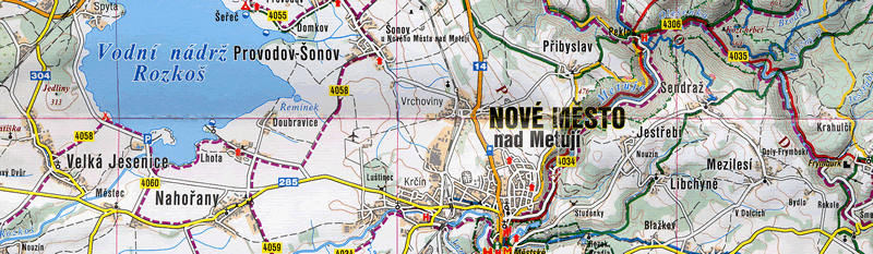
Digital map
The digital map is slightly different to the printed map in as much as the captions (place names Etc) are often a slightly different scale and orientation, but the basic cartographical information is the same. It also doesn't quite cover the same area as the printed map.
Digital maps are only available from this page on the live intranet on-site at Nové Mesto nad Metují.
- A bitmap suitable for MicroFlap [12 Mb]
- A .tif file with a pre-prepared .map file which calibrates it for the registered version of Oziexplorer. [14 Mb]
- An .ozfx3 file and associated .map file which calibrates it for the registered version of Oziexplorer. [13 Mb] (.ozfx3 is a proprietry format optimized for Oziexplorer).
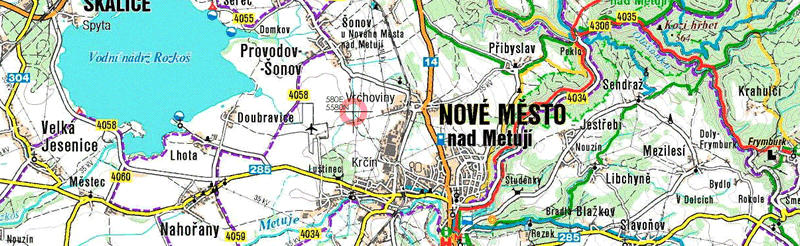
If you want to use the map in other software, the map datum is WGS84 and the projection is UTM Zone U33. To calibrate it, ten points have been placed on it which correspond to the same UTM grid as on the printed version. As an example, you can see the point 580000E 5580000N just to the east of the airfield. Extensive real-life checks confirm these points are accurate to within one or two pixels.
To convert from UTM to lat-lon, a good place to start is Ed Williams' Aviation formulary.