


Flying Saturday
Closing information
Task numbering
2 hour complaints deadline
task 18 is go!
Task 18 info
Types of Aeroplanes
Form for aeroplane types
Friday weather 2
Friday weather 1
Team leaders briefing
Next Team leaders briefing
Coaches to Old Warden
Old Warden route
Bad Weather for today
CIMA meeting 12 Aug
WL2 task 3 error
Engine to stop Task14
Route to SP - task12
Wednesday Weather
Track review system
Wednesday tasks TL briefing
spare t-shirts
AL2 task 7 error
pasta party on Wednesday
Weather Tuesday
beer and t-shirts
Team leaders next breifing
Sunday weather
Task 4 detail changes
Flying Sat 7th
Opening Ceremony
Weather saturday 7th
Questions asked by British team
Decision on radio carriage
Weather warning
Deck practice Friday AM
Friday 6th weather forecasts
Use of toilets in office block
TL Briefing Thur 5th
Thursday 5th Aug Weather
Competition Numbers
Those pesky Gate Codes
Official documents
Complaints
EMC2010 competitor list
internet dongle
site info 1
EMC2010 Bulletin 2 v4
Mailing list
Flying to EMC App F Sywell Inbound
Flying to EMC App E Sywell 2nd Leg
Flying to EMC App D Sywell 1st Leg
Flying to EMC App G Sywell Outbound
Flying to EMC 2010
EMC Local Information Guide
standard operational procedures V1
Registration form
Entries
EMC 2010 BULLETIN 1 v3
Local regulations v4
Tasks
EMC2010 Task 18
Task 15 start list
Task 17
Task 16
Task 15
EMC Task 14
EMC2010 Task 13 v2
Task 12 V2 2
Task 12 start list
EMC2010 task 13 PP landing
Task 12 2
EMC Task 11
Airspace task 10
Task 10 V2
Task 10
Fuel weighing this evening
Task 8 notes
Task 8
EMC 2010 Task 9
Sutton joining info
Task 4 notes
Task 4 Sutton-Sywell pipeline V3
EMC2010 task 5,6,7
Task 3 start times
Notes on tasks 3 and 4
Task 4 Sutton-Sywell pipeline V2
Task 3 Waterway to Sutton V2
Task 4-Sutton - Sywell pipeline
Task 3-Waterway to Sutton
EMC 2010 Task 2
EMC Task 1 - Spitfire
Task 1 - Spitfire start list
Spitfire V2
Spitfire
Practice task start list
Practice task - IFR version 2, changes in red
Practice task - IFR
WL1 scores
WL1 TOTALS v12 OFFICIAL
WL1 Task 18 v2 OFFICIAL
WL1 Task 8 v4 OFFICIAL
WL1 TOTALS v11
WL1 Task 8 v3
WL1 TOTALS v10
WL1 Task 18 v1
WL1 TOTALS v9
WL1 Task 14 v2 OFFICIAL
WL1 Task 12 v2 OFFICIAL
WL1 Task 13 v2 OFFICIAL
WL1 TOTALS v8
WL1 Task 14 v1
WL1 Task 10 v3 OFFICIAL
WL1 TOTALS v7
WL1 Task 12 v1
WL1 Task 11 v2 OFFICIAL
WL1 Task 13 v1
WL1 Task 10 v2
WL1 TOTALS v6
WL1 Task 11 v1
WL1 Task 10 v1
WL1 Task 9 v3 OFFICIAL
WL1 Task 9 v2 OFFICIAL
WL1 Task 8 v2
WL1 Task 6 v3 OFFICIAL
WL1 Task 4 v3 OFFICIAL
WL1 Task 3 v4 OFFICIAL
WL1 TOTALS v5
WL1 Task 9 v1
WL1 Task 8 v1
WL1 Task 7 v2 OFFICIAL
WL1 Task 5 v2 OFFICIAL
WL1 Task 2 v4 OFFICIAL
WL1 TOTALS v4
WL1 Task 3 v3
WL1 Task 6 v2
WL1 Task 4 v2
WL1 Task 3 v2
WL1 TOTALS v3
WL1 Task 4 v1
WL1 Task 7 v1
WL1 Task 2 v3
WL1 Task 6 v1
WL1 Task 3 v1
WL1 Task 5 v1
WL1 Task 1 v4 OFFICIAL
WL1 Task 2 v2
WL1 TOTALS v2
WL1 Task 1 v3
WL1 Task 1 v2
WL1 TOTALS v1
WL1 Task 2 v1
WL1 Task 1 v1
WL1 Entries v7
WL1 Practice Task v1
WL1 Entries v6
WL1 Entries v5
WL1 Entries v4
WL1 Entries v2
WL1 Entries v3
WL1 Entries v1
WL2 scores
WL2 TOTALS v16 OFFICIAL
WL2 Task 18 v2 OFFICIAL
WL2 TOTALS v15
WL2 Task 18 v1
WL2 TOTALS v14
WL2 Task 8 v4 OFFICIAL
WL2 Task 12 v4 OFFICIAL
WL2 Task 3 v10 OFFICIAL
WL2 Task 14 v2 OFFICIAL
WL2 Task 13 v3 OFFICIAL
WL2 Task 12 v3
WL2 TOTALS v13
WL2 Task 8 v3
WL2 Task 3 v9
WL2 Task 14 v1
WL2 Task 12 v2
WL2 Task 13 v2
WL2 TOTALS v12
WL2 Task 10 v3 OFFICIAL
WL2 TOTALS v11
WL2 Task 12 v1
WL2 Task 11 v2 OFFICIAL
WL2 Task 13 v1
WL2 Task 10 v2
WL2 TOTALS v10
WL2 Task 11 v1
WL2 Task 10 v1
WL2 Task 9 v2 OFFICIAL
WL2 Task 4 v2 OFFICIAL
WL2 Task 3 v8 OFFICIAL
WL2 Task 8 v2
WL2 Task 7 v4 OFFICIAL
WL2 Task 5 v5 OFFICIAL
WL2 TOTALS v9
WL2 Task 9 v1
WL2 Task 8 v1
WL2 Task 6 v3 OFFICIAL
WL2 Task 1 v7 OFFICIAL
WL2 TOTALS v8
WL2 Task 3 v7
WL2 Task 3 v6
WL2 Task 3 v5
WL2 Task 3 v4
WL2 Task 3 v3
WL2 Task 5 v4
WL2 Task 7 v3
WL2 Task 5 v3
WL2 TOTALS v7
WL2 Task 6 v2
WL2 Task 5 v2
WL2 Task 3 v2
WL2 Task 7 v2
WL2 Task 4 v1
WL2 Task 7 v1
WL2 Task 6 v1
WL2 Task 3 v1
WL2 Task 5 v1
WL2 Task 2 v3 OFFICIAL
WL2 TOTALS v6
WL2 Task 1 v6
WL2 TOTALS v5
WL2 Task 1 v5
WL2 TOTALS v4
WL2 Task 1 v4
WL2 TOTALS v3
WL2 Task 1 v3
WL2 TOTALS v2
WL2 Task 2 v2
WL2 Task 1 v2
WL2 TOTALS v1
WL2 Task 2 v1
WL2 Task 1 v1
WL2 Entries v9
WL2 Entries v8
WL2 Entries v7
WL2 Entries v6
WL2 Entries v5
WL2 Entries v4
WL2 Entries v3
WL2 Entries v2
WL2 Entries v1
AL2 scores
AL2 TOTALS v13 OFFICIAL
AL2 Task 18 v2 OFFICIAL
AL2 Task 8 v3 OFFICIAL
AL2 Task 7 v5 OFFICIAL
AL2 TOTALS v12
AL2 Task 18 v1
AL2 TOTALS v11
AL2 Task 12 v4 OFFICIAL
AL2 Task 14 v2 OFFICIAL
AL2 Task 12 v3
AL2 Task 13 v2 OFFICIAL
AL2 Task 11 v5 OFFICIAL
AL2 TOTALS v10
AL2 Task 14 v1
AL2 Task 12 v2
AL2 TOTALS v9
AL2 Task 12 v1
AL2 Task 11 v4
AL2 Task 13 v1
AL2 Task 11 v3
AL2 Task 11 v2
AL2 Task 10 v2 OFFICIAL
AL2 TOTALS v8
AL2 Task 11 v1
AL2 Task 10 v1
AL2 Task 7 v4
AL2 Task 9 v2 OFFICIAL
AL2 Task 3 v6 OFFICIAL
AL2 Task 8 v2
AL2 Task 1 v6 OFFICIAL
AL2 Task 7 v3 OFFICIAL
AL2 TOTALS v7
AL2 Task 9 v1
AL2 Task 8 v1
AL2 Task 6 v2 OFFICIAL
AL2 Task 5 v2 OFFICIAL
AL2 Task 4 v2 OFFICIAL
AL2 TOTALS v6
AL2 Task 1 v5
AL2 Task 3 v5
AL2 Task 3 v4
AL2 Task 3 v3
AL2 Task 7 v2
AL2 Task 3 v2
AL2 TOTALS v5
AL2 Task 4 v1
AL2 Task 7 v1
AL2 Task 6 v1
AL2 Task 3 v1
AL2 Task 5 v1
AL2 Task 2 v2 OFFICIAL
AL2 TOTALS v4
AL2 Task 1 v4
AL2 TOTALS v3
AL2 Task 1 v3
AL2 TOTALS v2
AL2 Task 1 v2
AL2 TOTALS v1
AL2 Task 2 v1
AL2 Task 1 v1
AL2 Entries v6
AL2 Entries v5
AL2 Entries v4
AL2 Entries v2
AL2 Entries v3
AL2 Entries v1
GL2 scores
Team scores
TEAM ALL v20 OFFICIAL
TEAM ALL v19
TEAM ALL v18
TEAM ALL v17
TEAM ALL v16
TEAM ALL v15
TEAM ALL v14
TEAM ALL v13
TEAM ALL v12
TEAM ALL v11
TEAM ALL v10
TEAM ALL v9
TEAM ALL v8
TEAM ALL v7
TEAM ALL v6
TEAM ALL v5
TEAM ALL v4
TEAM ALL v3
TEAM ALL v2
TEAM ALL v1
Tools
Championship Logo
Maps
Intranet management
Site map
microFlap simple guide
RSS feed
Mobile intranet
MLR
MicroFlap
FRDL and AMOD
Flight tracks
Air Observer
30 Jul 2011 10:09 BST
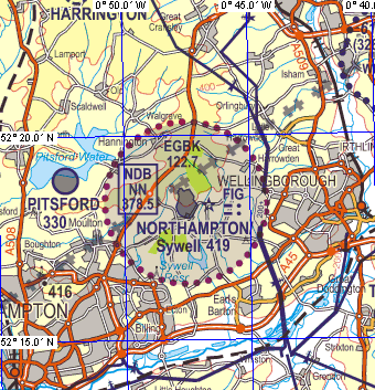
Maps
The official map of the championship will be the UK CAA Topographical Air Chart 1:250,000 Sheet 8, England South Edition 14, published 8 April 2010.All pilots will receive one copy as part of their entry fee.
If you are planning on flying from the channel coast to Sywell you will either need this map, or the 1:500,000 Southern England and Wales chart Edition 36 published 11 March 2010.
Warning Do NOT rely on older editions of either of these maps to navigate from the channel to Sywell as there are some new features exactly on the route such as a new Transponder Mandatory Zone (TMZ) around Stansted CTR.These maps may be obtained by mail order from retailers such as Pooleys or Transair
UK CAA publish a useful VFR guide for pilots not familiar with UK maps and VFR procedures.
The map looks like this, here overlaid with blue lines of latitude and longitude.
A zip file containing a .tif of the map in the championship area and a .map file calibrating it in oziexplorer
is available from this page on the on-site intranet.
![]()