
News release: 29 Apr, Somersby | |
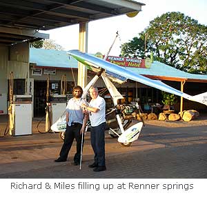 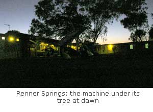 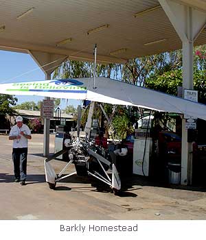 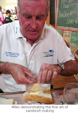 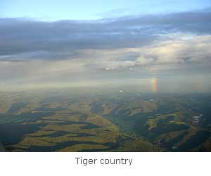 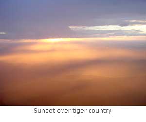  | Yey, we're a mere 40 miles from Sydney! On our day in Darwin Peter Lymn, CHC's base manager in Darwin was incredibly kind and got me more-or-less sorted with maps. I visited Dot Meakins whose husband Greg out at Truscott had offered me what he had, and the flying club had most of the rest in stock. WAC charts are 1 million scale the same as the ONC's I've been using all along, but rather small, so you need quite a lot of them. I was missing just one for our intended route across to the East Coast and down to Sydney but with the aid of a whole of Australia road map from a garage at least I now had a good idea where we were going. I still was missing the two Visual Terminal Charts I'd need for the Brisbane and Sydney areas but I thought I would be able to find them as we went along. I met a chap in the CHC hangar who said he was the pilot who had guided Brian Milton into Troughton Island all those years ago. It's a small World! Although there seems to be thousands of light aircraft about in Australia, I asked about the availability of fuel. I was told it's available at many airfields but you need a special fuel card. Of course we had no time to get one, but I expected we'd manage one way or another. "What about airport landing and parking fees?" I asked. Don't worry about it, I was told, if someone wants to charge you something, they'll find you. I removed the life raft and the remaining pannier tank which we'll no longer be needing, returned the fuel system to what it was like before Kupang and changed the oil and plugs. I also jettisoned stuff like our life jackets - no more sea! There seems to have been a terrific lot of sea on this journey, I must add it all up once I've got all my maps back, I bet it comes to a couple of thousand miles at least. Considering Darwin is such a small town, 100,000 residents I was told, I was surprised by the number of stories of murders and other violent crimes carried by the Northern Territory News, in fact we seemed to be their only 'feel-good story' of the day. Someone told me it was because Darwin is not always a very pleasant place to live, especially in the 'wet' when it's extremely hot and humid. Politely, it's still considered a bit of a frontier town, but I'm afraid I laughed when it was rather more graphically described to me as being full of people from 'the shallow end of the Australian Gene pool'. There was a surreal moment in the bar of our hotel when someone said "you-know-who's father is here". He didn't stay long and I never had a chance to talk to him but I gather he was on holiday and as mystified as anyone why his son had deserted the expedition at such a late stage. The night before we left Darwin, Peter took us to a great steak restaurant in town - Miles predictably ordered a salad and Peppercorn steak. It rivalled anything you get in Argentina, which means it was bigger than the plate it came on. I had acquired an all-Australia road map from a garage and we made the plan for the customs man to send to Interpol. The bank wanted us to be in Sydney on Monday morning, so in theory we had five whole days to get there. The route looked like Tennant Creek, Mt Isa, Charleville, Coolangatta, just south of Brisbane near where my brother Luke lives, to Gosford just outside Sydney. Considering everyone was saying the prevailing wind would be against us the whole way I thought it was a very tall order. Didn't they realize how big Australia is? Darwin to Sydney is the same sort of distance as flying from Scotland to Istanbul, albeit without the hassles of crossing borders. Five days, with perhaps a half day in reserve it had to be though; Miles was booked for an important breakfast TV show in Sydney on Tuesday morning and on a flight to the Philippines that afternoon to start a tour of speaking engagements for Seeing is Believing in Manila, Hong Kong and Seoul. Next morning was ANZAC day. For a while I thought we weren't going to be able to get a taxi to the airport because they were all busy taking people to the traditional dawn remembrance services, but there was a service and parade near our hotel so we caught a 'return trip' which got us to the CHC hangar just before dawn. It took a while for their 2 Super Pumas to clear off to Dili in East Timor and I didn't dare take the machine out of the hangar until they'd gone. While I'm getting everything ready loading up the panniers, connecting up Miles' computer, pre-flighting the machine and so on, Miles is usually chatting to someone. Miles is very systematic about the way he puts his flying suit on and stuff, which is a good thing, but always takes ages, so I've got the point at which he should start getting ready fairly fine tuned so I shouldn't have to stand around baking in my suit waiting for him. Nevertheless, I'm usually in a good sweat when we're ready to start up because he usually contrives to create some sort of delay, often the phone call to Jon giving an ETA for where we're going, or for someone to take a photo of us or something which he could have perfectly well done a bit earlier. In Darwin there was another delay as I was transferred from the ground frequency to 'clearance'. For a horrible moment I thought they were going to make us go to an office somewhere the other end of the airport to file flight plans and pay and things but I explained we were going to Daly Waters to refuel and then on to Tennant Creek. We would be going down the road, and didn't need a SARtime or anything. They seemed happy with this and we were sent on our way. It was great to be back in a land of the sane where you only need to file a flight plan if you, rather than they, think it's important. Flight plans are actually a good thing in the circumstances for which they were originally conceived. It's a special form laid out in a common format from which some of the information is telexed to your destination in a special code. The idea is that if you don't turn up someone should come looking for you. The information which isn't sent as standard is stuff like your fuel endurance and what sort of comms and safety equipment you're carrying which is useful if you do disappear. Unfortunately their original purpose has been corrupted by governments so they can keep tabs on you, you're supposed to file one on every international flight, even if it's 10 miles across a perfectly safe border, say from France to Luxembourg, (needless to say, people don't) but every country we've been through since Europe has insisted on a flight plan for every flight, even if it's not an international one. In the great scheme of things they don't take long to do (except for India), but it always adds to the general hassle. As with the flight out of Truscott it was pleasantly calm, but very slow. We were doing around 40 Kts on the ground straight into the South Easterly wind everyone predicted we'd get all the way to Sydney. Our route followed the Stuart Highway, 'The track' as it's known locally, and the new railway which in 2004 finally completed the link to Adelaide, 75 years after the first train entered Alice Springs. Near the road, every twenty miles or so, I could see the overgrown remains of what must have been wartime airfields hacked out of the quite dense bush similar to Truscott. I suppose this must have been some kind of defensive retreat system they'd organized to deal with a Japanese invasion. After a while it became clear we weren't going to make Daly Waters. The alternative was Tindal just outside Katherine which I'd wanted to avoid as it looked like a great big air base and there were pages and pages of complicated looking instructions about landing there in my newly acquired ERSA guide to airfields in Australia. As we got near I tried all their radio frequencies and got nothing except silence in reply until I found one which said firmly "Tindal airfield" whenever I transmitted; it didn't matter what I said to it, it always replied the same thing. I assumed that because it was ANZAC day they were having the day off, leaving a robot on duty. The place was deserted; lots of hardened hangars and things but nothing in them. There was a fuel pump on the small civilian apron but didn't seem to be anyone about apart from someone washing his aeroplane by a hangar, he came over to tell us he'd seen us on the TV. This was Dr Andrew Bell who has done great work over the last 15 years or so improving the medical services delivered to Aboriginal communities within the vast Katherine West region. I'd heard that alcohol was a significant problem and is banned in aboriginal areas, but wondered how this is actually implemented. It's apparently the communities themselves which ban it, and this is backed up by the NT Licensing Commission. If you're found with alcohol in your car in any of these areas then your car is usually confiscated. I asked how one got hold of the fuel man, but it was self service - with one of the cards we didn't have. Andrew very kindly filled us up on his and I gave him the cash. Apparently these self service pumps are very common; I supposed we were going to be lucky to have someone about with a fuel card in every place we stopped, but we'd face that when we came to it. Just in case we didn't make Tennant Creek he gave me the locations of four petrol stations on the way. The radio robot is perfectly normal practice apparently, ATC is rare at even quite busy airports, something we'd already seen at Kununurra, and if there is more than one aircraft about then the pilots just sort things out between themselves. After so much ATC control on this trip it's still taking me a while to get to grips with such sensible arrangements. Climbing out of Tindal was pretty turbulent; normal afternoon stuff in central Australia. Andrew said there was usually an inversion at six or seven thousand feet and it would be alright above that. There was a noticeable temperature change at about 6000 ft and it settled down. We were going no faster until about 30 miles from Tindal when the road turned south and we picked up speed to about 50 Kt on the ground. I wasn't wildly enthusiastic about this as I knew that from tomorrow we had two or three days going due east right into the teeth of it. Miles wanted to know why we didn't just go direct south east now, after all, we'd spent most of the journey flying over inhospitable terrain, so why not now? I supposed we could, but it took a while to convince him that if we did then we would fly on an on and just run out of fuel before getting anywhere because there just isn't anywhere to go to if we went that way, and secondly, we were in a rush to get to Sydney. If we had an engine problem over the road we could safely land on it and someone would soon be along to help, whereas out over this quite dense bush we would probably crash and nobody would find us for ages. On the whole Miles is a pretty easy bloke to get along with but he kept on at this for quite a while to the point that I came the closest to losing my temper thus far in the whole trip. I threatened to land on the road and as he was such a famous pilot he could take off and fly off into the boonies himself if he liked, but I'm staying by the road. We passed Daly Waters, lucky we didn't land there as the garage was a couple of miles from the airfield. As the afternoon wore on we got pushed higher and higher until we were at 9500 ft to keep above the turbulence, there were a few weak little puffy clouds about which showed where cloudbase was. Elliott was next, and by now it looked unlikely we would make Tennant Creek both because of our fuel and the remaining daylight; we might have made it had there not been the delays first thing that morning. The most likely looking place to stop was Renner springs which Andrew said was a garage, he didn't know whether it had a strip, but he thought probably not. My map didn't show one, but then it only seemed to show some as I'd seen quite a few unmarked ones at the cattle stations we'd passed. Renner Springs came up, Miles wanted to know how big the town was, it took a while convincing him that it wasn't a town, just a couple of houses and a garage, and that was it, and no airstrip. He was very excited by the prospect of landing on the road, I was a bit more wary, not because of the traffic, there was hardly any, but because of a little incident I had a few years ago with a road sign in Norfolk. As we circled round, there looked to be quite a lot of them about. I landed in a wide enough gap about half a mile up the road from the road house, turned round quickly and, taking care of about a dozen signs, accelerated back up the road before anything came. We got a few strange looks as we taxied in, but soon they realized we were the people they'd seen on the TV and made us very welcome. I filled up the machine at the pumps and parked it under a tree between the garage and the motel; very convenient for the morning. They had very nice cold beer. Places like this are a whole little World really, the nearest shops are in Tennant Springs 250 Km away, but there's always some traffic and something going on, I wondered who the people were who drive up and down this road. There's the road trains of course, and this time of year quite a lot of people are going north for the winter with caravans, or people with boats either going there or coming back from Barramundi fishing which is a big thing up North. Then there were miscellaneous people like a soldier based in Darwin who was doing the three day drive down to Adelaide to get there in time for his daughter's 4th birthday. It’s the road trains which form the bulk of the traffic though; they're the massive triple trailer trucks they have in these parts. I got talking to one of the drivers who said he had an Airborne microlight at home in Bathurst near Sydney, though he hadn't flown it for three years. Airborne are Australia's best known microlight manufacturer and they send them all over the World, I've seen them in UK, US, France, Jordan, Indonesia and China. Thinking it must take about a week, I asked how long it takes him to get from Sydney to Darwin in a road train. "50 hours" was the reply, "We never really stop for more than about an hour to grab something to eat, like here. The rest of the time me and my mate, we do 6 hours shifts day and night. We'll be in Darwin first thing tomorrow morning and if we're unloaded quickly we'll be on our way back after lunch. We do a round trip each week; our truck is only 3 months old and it's already done 75,000 Km." I said we're going so slowly I'd wave as he passed us somewhere around Mt Isa. These are very big trucks, they must be the biggest 'ordinary' road vehicles anywhere in the World; true kings of the road. His rig weighed 125 tons, the fuel tankers, he said, go up to 175 tons. I dragged Miles out of the bar to have a walk down the length of it before they left. He was impressed. There were two maps on the wall of the bar. One was of the Northern Territory, sub divided into what looked like counties but were actually properties the size of counties. This is very big cattle country but extremely marginal. The station adjoining the roadhouse was run by a neighbour and had stock on it for the first time in three years, the fences weren't very good and they had a significant problem with cattle being hit by vehicles on the road. The other map was a huge representation of Australia painted on a wall. I showed Miles where we'd been today, and where we had to get to in the next four days. I was very pessimistic about being able to make it against this headwind, it seemed an impossible task but all we could do was battle on as best as we could. I did my flight planning for the next day in the bar, it was the best place to find out where we could get petrol. We were planning to get to Mt Isa next day, a mining town in Northern Queensland. Although only 140 Nm, we would have to stop at Barkly Homestead, another roadhouse, as there was nothing after that until Camooweal, a further 140 Nm and there was little chance of doing 280 in this headwind. Mt Isa is 90 Nm beyond Camooweal. The TV that night carried news of the various ANZAC day events around the country, it was absolutely pouring with rain in Sydney and Brisbane. Miles might complain that I'm prone to going to sleep with the TV on, but once programs are finished for the night ABC (the Australian BBC) broadcast a rather good satellite map of Australia. I woke in the middle of the night to see a huge swirl of cloud covering Victoria and New South Wales and extending up the east coast to southern Queensland. We were miles north of it here but would need to take some advice further on. Because the microlight was parked so conveniently close to where we were staying we were ready to go well before sunrise. With no mobile phone signal Miles couldn't create his usual delay but the engine played a new trick on me by showing no oil pressure at all, or, I hoped, too much to read, until the oil temperature had risen to about 35 degrees. After that it seemed fine and we caught a glorious sunrise just after takeoff. Relenting a little bit from my determination to stay by the road all the time, I'd planned a straight line to Barkly Homestead cutting off the corner of where the road turned east at three ways by about 50 miles. Very shortly after takeoff the engine started sounding like a bag of nails and I throttled right back to a slow cruise and decided to stay close to the road after all. I could only think that the 95 octane 'premium' we'd filled up with wasn't what it said it was on the pump and was perhaps the regular 90 octane. At least it was a lovely calm morning. Initially I thought we should stop at three-ways and decant all our fuel and start again but even though the engine didn't sound too good, the temperatures looked OK, and landing there would certainly introduce a delay which would almost certainly prevent us getting to Mt Isa, so we carried on at our slow cruise to Barkly Homestead, but always within reach of the road. They had a very nice dirt strip and I taxied up a dirt road, through the campsite right up to the pumps. I gave them the 40 litres we had remaining for their mower. The chap said not so many people buy premium so it was possible the stuff we'd bought had been in stock for a while and had simply degraded in the heat. This time the premium was fine, but it had become very turbulent and it took a while to get above it. At 6000 ft the wind wasn't as bad as I'd feared and we were making around 55 Kts on the ground. Same as the day before, we gradually got pushed higher and higher as the afternoon thermals grew, until we were just under 12,000 ft. At this height it's somewhere around 8 deg, Miles was shivering, but urged me to climb over 12,000 just so he could say we'd been there. Since he got a touch of frostbite in Antarctica Miles' hands are very sensitive to the cold but he's left the power cable for his electric gloves behind somewhere so can't drive in these conditions for more than a few minutes. We passed Camooweal and if anything our ground speed increased a bit, I thought we had the fuel to carry on a further 60 miles or so beyond Mt Isa to Cloncurry. The landscape changed from being almost open spinifex desert to what one might call the 'badlands' of the Selwyn ranges, a series of muddled ridges and valleys running more or less north-south across our route to Cloncurry. These hills were well known to prospectors of the late 19th and early 20th centuries. John Miles found a massive deposit of lead and silver and Mt Isa was born in 1923. Based on the combined production of lead, silver, copper and zinc it became what some say has been the most productive single mine in world history. I could see the white 885 ft 'Lead stack' chimney from 40 miles away. Cloncurry airfield had one of those robots in control so I just called finals, landed and parked in front of a small terminal building. A chap came over and said I'd better move because the flights were coming. Five minutes later three quite large commuter aircraft arrived packed with miners from Townsville and Brisbane. In the evening light I got chatting to some young pilots hanging around a fleet of R22's parked outside a maintenance hangar. I commented on how tiny they looked. "Speak for yourself" they said! Robinson R22 helicopters are the standard machine for cattle mustering these days; this outfit had 18 of them, none had doors fitted, some had an external oil filter for easy maintenance but otherwise they're standard 'out of the box' aircraft. They all carry a pump to refuel from drums when they're out on a job. With so many, I imagined it must need several to muster a herd of cattle, but no, "one machine can do about 1500 head, 2000 at a push. I've been on a few jobs where there's been two of us. I've heard of really big herds up north where they use 5, but that's very rare." Their normal operational area is about the size of France or Spain, I'm finding it difficult to get to grips with just how huge Queensland is. When I said we'd been flying up at 11 or 12 thousand feet for most of the afternoon they were astonished; "some of our chaps get scared above 100 ft" one said. Their work is all done at very low level; "The advantage of a helicopter over a fixed-wing or a microlight is when you get a stubborn beast standing under a tree, we can hover over it until it moves, and if it still won't move we shoot it with a shotgun loaded with rubber bullets; then they move!" I asked how often they crashed. "We reckon on one write-off a year", one said, grinning at one of the others; "but pancaked skids and things are quite common." He continued: "My blue one over there has a big dent in it where it was charged by a cow a few days ago". Apparently he'd landed to disentangle a cow from a fence, once free, the enraged creature had charged the helicopter by way of thanks. As we talked a couple of their R22's landed back from jobs, somehow you could tell these guys were very proficient pilots, none of that wobbling about you often see as they land, just a businesslike, no-nonsense arrival. It's a hard way of life; dusty and dirty, usually miles from anywhere, but I should think an unsurpassed way of racking up hours in small helicopters doing things they weren't necessarily built for. In the meantime Miles had been chatting to a fellow who offered space in his hangar for the night. All there remained to do was fuel up and we could go to our hotel. As usual they had one of those fuel pumps which only takes the special card. As I've no doubt their company pays for their fuel, the helicopter chaps were more than happy to take my cash. One of them had just flown up from Sydney with a new machine. Although they're a bit faster, we have a superior range than a R22. He had lots of useful advice about which way to go and where there was fuel. He proposed we should follow the Mitchell highway south, keeping inland of the Great Dividing Range. This meant not going via Coolangatta near where my brother Luke lives on the coast which was a bit of a disappointment, but having seen the weather there on TV, staying inland seemed a much better idea. The only problem with this plan was I didn't have the two WAC maps covering the route. They didn't have any either, but it's big cattle country and they thought I'd be able to manage perfectly well with my all-Australia road map. We got news that Dick Smith was organizing some sort of special routing for us through Sydney harbour which sounded exciting, and that immediately afterwards the machine should be delivered to Rob Hibberd at the Airborne factory a couple of hours north in Newcastle to be crated up and sent for immediate display in a Hong Kong shopping mall. This sounded like madness to me, a huge expense, and who was going to de-crate it and rig it there? I thought that I would be definitely prefer to be getting seriously stuck into a few cold beers rather than an argument with Hong Kong customs; I hoped that whoever the organizer was of this plan would see some sense. We stayed in the Leichardt motel. The owner Billee Telford said her husband Jim was a veteran flier and would have been fascinated to hear our story, but was presently having a cancer operation in Brisbane. She said that Jim had to have a sit in his aeroplane in the hangar before he left for the hospital which seemed to revive his morale enormously. She donated our bill to Seeing is Believing which was an incredibly generous gesture especially at such a desperate moment in her life. We wished Jim well. The satellite photo on ABC was still showing a huge weather system south to us; it was still raining in Sydney and looked like we were going to get wet at some stage, but probably not tomorrow. We couldn't possibly begrudge any rain as the whole of south east Australia is in the sixth year of a serious drought which in an inimitable Australian way has become known as 'the Great Dry'. It was fortunate our taxi driver had a torch in the morning for we were there well before dawn. The book says this is a 'Security Controlled Airport' but we'd been shown the hole in the fence where you get in. Just as it began to get light some helicopter boys departed off on jobs with their floppy hats in the under seat locker and swag strapped into the passenger seat. My engine played its new oil pressure trick again, but settled down once it had warmed up a bit. Our day's flying was across Qantas country. There seems to be some dispute as to where Queensland And Northern Territory Aerial Services was actually founded, it seems Winton, Charleville and Longreach all have claims, but it was in November 1920 which makes Qantas one of the World's oldest continuously running independent airlines. As seems to be the usual thing now, we were airborne just before sunrise in perfect flying conditions. The rough hilly land soon gave way to vast open ranch land. This is classical Australian outback; even the smallest settlements along the way seemed to have a horse racing circuit. We passed Winton which has a museum dedicated to Waltzing Matilda, Australia's most widely known folk song written by the poet and nationalist Banjo Paterson in 1895. I'd planned our next stop to be Longreach, where I'd been told "you can see the Jumbo from miles away", and then, if we were lucky with the wind, Charleville. This was the exact reverse of Qantas' first commercial flight from Charleville to Cloncurry in an Avro 504K. It had a cruising speed more or less exactly the same as our GT 450 but carried two passengers rather than my one in an open cockpit behind the pilot. Longreach was in the centre of Quantas' early operational area and was where they built their own de Havilland DH50s between 1926 and 1929 making it the only airline to have ever have built its own aircraft. The Quantas Founders Outback Museum there has ambitions to have one of every kind of aircraft they ever operated. In 2002 a retired 747-400 was added to the collection amidst much speculation as to whether it would land without crashing. Although rather short, the problem was not so much the length of the runway as the width which meant the two outer engines had to be shut down for risk of picking up gravel, so it only had reverse thrust available on the inner two for deceleration. They were right about being able to see it from miles away, but with a completely unexpected ground speed of nearly 70 Kts we were going so well I decided we could easily get to Barcaldine about 50 Nm further on, so we passed Longreach by on our right hand side. The only problem with Barcaldine could have been fuel, but, as the chap at the pump said as soon as I'd got my helmet off, "nobody buys fuel from me for weeks, then it's two at the same time". He was filling up a load of drums in the back of a ute belonging to Bevan Doyle, a farmer who's been flying the same Beechcraft since he bought it second hand in America in the early 1960's. "I don't use it as much as I used to as the roads have improved so much in the last few years, but I couldn't ever sell it". I had noticed this as we were flying along, last time I was in Australia aged 19 even the main road across the Nullabor joining Western Australia to the rest of Australia wasn't all tar. These days even some quite small rural roads are sealed. I mentioned my lack of maps for our new route and our fuel man said he probably did, and went off into town to get them. I got talking to Bevan about the drought; it wasn't so bad here, he said, because they were bang in the middle of the great artesian basin which was showing no signs of shortage, but down south he said it has been pretty desperate. The rain they're getting now is too late in the season to have any real effect and they're just having a 'green drought' where everything goes green for a bit but it's too cold for there to be much growth. The gift of maps appeared. With many thankyous I roughly drew our route across them and in rather a strong wind we were soon on our way. As usual for the second flight of the day it was extremely turbulent climbing out of Barcaldine and it didn't settle down until we got to 10,000 ft. We passed Blackall, one of the reputed locations of 'the black stump'. The story goes that in 1887 surveyors used a blackened tree stump as the base for their measuring equipment and from there they were able to fix the positions of all the major towns of southern Queensland. Before long, people considered anything west of Blackall to be 'beyond the black stump'. As we went along we were driven higher to keep out of the afternoon turbulence and I could see in the distance the beginnings of what was probably that enormous weather system on the TV. There were lots of strange little lenticulars about at all different levels, some above us, some below and it was a bit like riding a giant roller coaster which occasionally came off the tracks. Eventually we got pushed up to 13,000 ft but there was still the odd rough patch, Miles was shivering a lot and I was quite cold too. We were going well, though not quite as well as in the morning, we had the fuel and just about the daylight to push on for another hour and a quarter to Cunnamulla but after nearly seven and a half hours already we decided to call it a day and land at our planned destination of Charleville. For once there was someone permanently there in the 'Charleville Airport Shop and Café'. We were soon filled up with fuel and had the machine squeezed into a vacant space in the hangar. We stayed at the Cattle Camp Hotel which could be described as a fairly typical outback pub where you can enjoy a schooner of cold beer, fish and chips and a flutter on the horses all at the same time. Miles thought it was very funny when our Finnish waitress got terribly embarrassed at the sheer political incorrectness of me showing her how clumsy blind people can be at making jam sandwiches for breakfast. I spoke to Dick Smith who confirmed he'd secured permission for us to fly the helicopter route through Sydney harbour. Some people describe Dick as 'the Australian Richard Branson'. Actually I think that does a disservice to Dick; they may both be tycoons, they may both be characters you either love or hate, but Dick is actually interested in flying much more than just by the balance sheet or by being a passenger on highly publicized balloon flights. Dick was the first person to pilot a helicopter around the World in the early 1980's and has since flown around the World in aeroplanes by a variety of different routes including via both poles. He'd been coordinating with Rob Hibberd at Airborne and we were to meet up early the day after tomorrow morning at Somersby, a microlight airstrip near Gosford, forty miles or so north of Sydney. As yet I hadn't got the vital VTC of the Sydney area, Dick said "get one" and he would brief me on procedures before we set off. Heavy rain on the tin roof of the motel woke me in the middle of the night. I studied the satellite photo on ABC carefully, there was a big belt of cloud across our path, perhaps as far as Bourke, four hours south. It was still raining hard as our taxi arrived just before dawn. The driver pointed out where the lower three-quarters of some road signs are painted brown to show where the water level got to in the famous1990 flood which inundated more than a million square kilometres between Charleville and Nyngan, just where we were going. We stood around in a gloomy hangar for half an hour, I watched (Miles listened) to the chap from the airport café driving around the airport at breakneck speed blasting away at trespassing Kangaroos with a rifle, I don't think he was a very good shot. It improved to a heavy drizzle, we still had a long way to go, the plan was to try to get to Dubbo on the West side of the Dividing range where I expected we could meet some more substantial weather but only 150 Nm from Somersby. May as well get on with it, I thought, not much different to ordinary English weather, certainly nothing like the stuff we'd encountered in Malaysia. I fitted the radio and GPS in the plastic bags I still had from Singapore and crossed my fingers while the engine showed no oil pressure until it was warm. We followed the road closely south, it follows the course of the Warrego river and there was a huge amount of standing water in the bush either side, the rain was continuous but not heavy, my shoulders and Miles' knees were wet but the big windscreen on a GT 450 does a pretty good job of sending most of it around and over you both. It cleared up before Cunnamulla, much sooner than I thought. To begin with there was a high overcast and visibility was magnificent, 60 miles or more across wide open cattle country. Even if it would have meant the belt of rain would probably have passed by completely in the night, when I saw that Cunamulla airport was about 10 miles out of town I was glad we hadn't carried on there the night before as it looked pretty deserted and we'd probably have had difficulty getting a hangar, fuel and transport into town. As we crossed into New South Wales the overcast cleared, the sun came out and small puffy clouds began to develop at a very low level, then very rapidly, in the space of an hour or so, cloudbase rose and the tops were up at 5 or 6000 ft. It was very pleasant weaving between them just above cloudbase at 2,500 ft or so, but it had grown so fast I was a bit worried what might happen later in the day. The wind was still the unusual north-easterly which strengthened as we progressed, our route taking us nicely more and more down wind. We were doing 75 Kts or so on the ground as we passed Bourke, traditionally the edge of the 'outback' where I'd planned to refuel, and careered on to Nyngan 90 miles further down a dead straight road. It turned out to be a bit of a mistake going to Nyngan; I hadn't studied my ERSA guide carefully enough, there was no fuel pump and the place was deserted apart from a shiny new CT-SW parked on the apron. The only hope was to ring the number on a sign by the gate which said ' Nyngan Motor Inn, free pickups for customers'. I explained my problem and even though I was patently not going to be a customer the chap there very generously came out and gave me a lift to a petrol station with the reserve tank even though he was very busy preparing for a Rugby Club dinner that evening. It occurred to me that if we could refuel in Dubbo quickly there might just be daylight enough to get to Somersby. I rang Rob Hibberd who explained more or less where it is, and said to ring him from Dubbo once I knew what we would be doing. We made the 81 Nm to Dubbo with the wind dead behind us in exactly an hour. The over development into rain or thunderstorms I'd feared would happen earlier on had stopped and it just settled into nice scattered puffy cumulus. The land had turned from cattle to wheat and it was rather like flying on a pleasant English afternoon, except bigger. Dubbo is quite a big regional airport but still had a robot on the radio. We pulled up to the pumps and I wandered over to a hangar containing some Saturday afternoon tinkerers playing with their aeroplane. They'd seen us on the TV and were more than willing to help with our fuel card problem to the extent that they very kindly donated the $40 or so it took to fill our tank to Seeing is Believing. With this wind I calculated there would still just about be enough daylight to make Somersby, "ooh - Tiger country" our friends said, "we never go over there". I thought we were just going to follow the road over there and down the Hunter valley and couldn't really see what the problem was, in fact having always imagined the Great Dividing Range to be just that, I was rather surprised to see the highest ground on our route would only be about 2000 ft. I rang Rob who said he'd alert his mate Kevin Magennis to meet us when we arrived. I still didn't have the VTC for the Sydney area and the map I did have showed rather a lot of complicated looking airspace associated with Williamstown Air Force base but the Hunter valley is Rob's home territory and he said "just keep south of the Hunter River and you'll be all right." Immediately after takeoff I thought the prop was making rather a strange noise. 'Not now!' I thought, and for the first time on the trip went round and made a precautionary landing. Time was of the essence if we were to get to Somersby so I stopped where we landed, shut down and leapt out to see if a prop tape had come loose or something. I couldn't see anything wrong so fired it up and we went. Immediately after takeoff it started making the funny noise again, but I well and truly had the bit between my teeth to get there by now and anyway it seemed OK if I throttled right back. We crept along at minimum speed climbing very slowly. I was wondering if the new oil pressure problem was doing something to the gearbox but we weren't going to get there by sunset by going this speed. The noise disappeared once the oil temperature was up to about 90 degrees and as we passed our second black stump in two days I increased revs to about 4500 and our normal cruise of about 65 Kt. This black stump story says that during the first decades of the 19th century Governor Darling established the 'Limits of Location', a line on the map beyond which it was illegal to live. This line ran through a farm called The Black Stump, it was suspected that free convicts and poor settlers were hiding stolen cattle 'beyond the black stump' away from the prying eyes of the authorities where they’d fatten them up before bringing them in for sale. Whatever is the truth behind the black stump, at only 150 Nm from Sydney we were no longer beyond it. As for Tiger country, it all seemed rather pleasant farmland as we crossed over the hills in the late afternoon sunlight. Either side of the valley my map showed the hills went up to 4000 ft or so and there was rain on them but we were flying through a comfortable 20 mile wide gap. The wind seemed to have dropped off quite significantly but I'd put where I thought Somersby was in the GPS and it was still showing we'd get there just in time. Several times I told Miles I could see the sea only to realize it was still impossibly far away to really be able to see it. The sun goes down quickly in these parts so I found on the map a couple of small airports more or less along our route and looked them up on the GPS just in case it became clear we wouldn't make Somersby. The Hunter valley runs more or less west - east to the coast, Somersby is 25 miles south of Newcastle where the river comes out into the sea. Obviously I wanted to cut as much of the corner off as I could, and this was indeed Tiger country. Very steep rough hills covered with forest, the sort of place I'm sure aeroplanes have disappeared and not been found for years. I skirted around the edge of it as far in as I dared. I could see ships at sea now, but only rain ahead. I said to Miles, "we're going to get wet again, but I'll try to skirt around it as much as I can, we're nearly there." The sunset was glorious, we had a full 360 degree rainbow around us for quite a while, unfortunately I was a bit too preoccupied wondering where Somersby was to really enjoy it, I knew it was only a small microlight strip, not necessarily very easy to spot and only a fairly vague description of where it was. We went through a minute or two of very light rain and then I could see it, just where Rob had described it close to a distinctive bend in the Motorway, a narrow strip of dirt and grass between tall trees. I circled round a couple of times and landed, rather fast, downhill on wet grass, one minute before sunset. "We usually land the other way", Kevin said, in the gathering gloom. After covering 541 Nm from Charleville in just over 8 hours I was thinking more along the lines of "ONLY 40 MILES TO SYDNEY" and "WE'VE MADE IT FROM DARWIN WITH A DAY TO SPARE" and "COLD BEER". I think Miles was thinking similar things. As it's their place, Kevin and Angela sorted hangarage for us and solved that important cold beer problem. Best of all, Kevin had one of those VTC maps I've been looking for since our arrival in Australia so I'm not going to be embarrassed when Dick Smith turns up to escort us through Sydney harbour after all. Against all my expectations it has taken only four days to fly the 1800 Nm from Darwin and we are more or less set for a grand arrival in Sydney tomorrow morning. Although very hard work, it's been a great pleasure flying across Australia so far; no flight plans, no paperwork and no fees. How different to most of the flight is that? |