|
Info Task 1, Precision takeoff & landing Task 2, Pure Navigation
Task 3, Speed triangle and out & return Task 4, Fast / Slow Task 5, Kicking Sticks Task 6, Navigation, precision & speed Task 7, Endurance Task 8, Kicking Sticks Final scores Summary
|
Task Sheet
Competitors briefing sheet
- Briefing: Sunday 11:00
- Photography required
- Limited fuel. Fuelling control 12:00 to 13:30 See Fuelling control sheet.
- Takeoff window: 15:00 to 16:00
- Task ends 18:00 (Zero score for returning after this time)
Speed triangle and out and return ECONOMY
Objective
With limited fuel, to fly around a circuit in the shortest possible time, return to the deck and kick a stick to stop the clock, and then, with the pilots remaining fuel fly in a given direction to a point of pilot choice as far away as possible and return to the deck.
Description
Fuel quantity allowed: 6 litres.
Part 1: Speed; The pilot take off time is noted (Feet leave the ground). The pilot flies to turnpoint 107, then to turnpoint 33 and back to the airfield where he kicks sticks and the time is noted. Photos should be taken of all THREE points.
Part 2: Distance; The course the pilot must fly is from the airfield > turnpoint 115 > point of pilot choice down the road to Fullopszallas > turnpoint 115 > the airfield. (Note: if the pilot does not reach turnpoint 115, only the photo of the pilot’s point is required, if the pilot passes turnpoint 115, TWO photos of turnpoint 115 are required, interspersed with the point of pilot choice.
Special rules
Land out before completing part 1: Score zero.
Land out before completing part 2: Score zero for part 2.
Enter the No Fly Zone: 50% overall penalty.
Failure to takeoff or land entirely in the deck: 20% penalty.
 |
The pilot may have as many attempts as necessary at striking the first stick.
Only ONE attempt is allowed at kicking both the second and third sticks.
If the pilot fails to kick either the second or third stick then for each stick tp = (tp + 5%).
Three arrays of sticks will be provided in the large space beyond the camping area. On approach to the task, pilots should choose a "free" group of sticks, however if, in the opinion of the marshals on duty a conflict with another aircraft existed both should kick only one stick and then depart on the rest of the overall task. Both pilots will then be given the opportunity to have ONE further attempt at this task as soon as possible after the end of the overall task.
Penalty for not handing declaration sheet to a marshal within 5 minutes of landing (to encourage rapid scoring): 50 points / whole minute thereafter.
Penalty for mis-declaration of distance: dp = dp - (difference between actual distance and declared distance x 2)
Scoring
Pilot score = 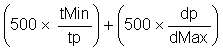
Where:
tp = the pilot’s time, Tmin = The best time (Part 1) dp = the pilot’s distance, dMax = the greatest distance (Part 2)
Photos
The centre line of the photo sector is back to the airfield in all cases, + - 45 deg.
IMPORTANT: The point the pilot photographs as his point of greatest distance in part 2 MUST be clearly and unequivocally interpretable onto the map. It is recommended the pilot takes several views of the point to confirm his position in relation to surrounding features and also takes back-up photos of earlier points along his route.
A trig point: Is a geographical point used in the surveying of maps.
On a map it is represented by the symbol : ![]() and a spot height.
and a spot height.
On the ground they are a structure c. 1m x 1m and usually (but not always) painted white. Check out the one on the hill immediately to the SE of the airport.
 |
Turnpoints
|
TP Ref. |
Details |
|
107 |
Trig point |
|
33 |
Trig point |
|
115 |
Crossroads |
